Fontaine de Nîmes

The drainage basin of the Fontaine de Nîmes, has a surface of about 55 km² and is located in the Garrigues around Nîmes with a part of the downstream basin located in an urban environment.

A KARST IN URBAN AREA

The BRGM has monitored the Fontaine de Nîmes since 1998, and this water source belongs to quantitative groundwater monitoring network (BRGM/ONEMA agreement) to respond directly to the objectives of the Directive Cadre sur l’Eau (portal ADES – www.ades.eaufrance.fr).

Hydrodynamic and physico-chemical measurements recorded at the spring, in surface water (cadereaux, which are dry streams used to channel rainwater), in borings or in cavities, augmented by geochemical campaigns have made it possible to describe the mechanisms responsible for the genesis or attenuation of flash flooding in the Mediterranean karst environment (Maréchal et al. 2008; Maréchal et al. 2009). Numerical modeling has improved flood forecasting (Fleury et al. 2013). Complementary tracing tests have also been conducted (Maréchal et al. 2010).

The network of hydrodynamic monitoring rests on the following data:

  • Discharge (8 hydrometric stations on the 5 cadereaux and 1 station at the Fontaine de Nîmes)
  • Piezometry (8 piezometric stations)
  • Pluviometry (9 rain gauge stations)
  • Hydrochemistry (spatial campaigns on the drainage basin)

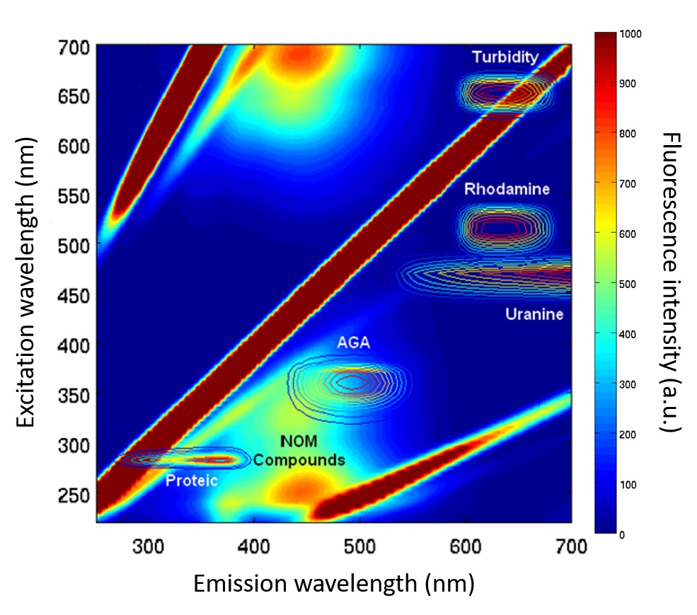
Since 2012, the measuring system has been enhanced by a fluorimeter that continuously (every 15 minutes) measures variations in natural fluorescence associated with the transport of dissolved natural organic and particulate matter. This continuous monitoring is supplemented by spatial campaigns making it possible to quantify Total Organic Carbon and to define the spectral signature (3D excitation/emission matrix) of fluorescent compounds.

Des Observations depuis 1887

The goal of this work is to:

  • Describe the dynamics of organic contaminant transfer in a karst system, using the strong anthropic signal on this system,
  • Define new indicators of rapid infiltration in a karst environment to describe better the qualitative state of the water and [spring pollution vulnerability.
  • Determine the relationship (non-linearity, seasonal effects, etc.) between natural fluorescence and the water’s organic content.

New scientific questions are approached within a collaborative framework with the UMR HydroSciences Montpellier, which has benefited from financial support of SNO Karst and IM2E.

Since 2012, the measuring system has been enhanced by a fluorimeter that continuously (every 15 minutes) measures variations in natural fluorescence associated with the transport of dissolved natural organic and particulate matter. This continuous monitoring is supplemented by spatial campaigns making it possible to quantify Total Organic Carbon and to define the spectral signature (3D excitation/emission matrix) of fluorescent compounds.

Visitez les 9 observatoires