Port-Miou is the submarine spring of a vast karstic hydrosystem in the lower limestone Provence, characteristic of the peri-Mediterranean karsts.
contact us
Coordination : Hervé Jourde / Naomi Mazzilli
Data Base : Juliette Fabre
Port-Miou is the submarine spring of a vast karstic hydrosystem in the lower limestone Provence, characteristic of the peri-Mediterranean karsts.
The submarines springs of Port Miou and Bestouan form a continuous flow of water from the continent that discharges into the sea. This underground water flows in karstic conduits of metric to decametric dimensions that were formed in the subsoil of the calanques from Marseille to Cassis, in lower limestone Provence. This hydrosystem of Port-Miou, represented by the emblematic spring of Port-Miou, goes far beyond the coastal zone and extends over a large part of the geological units of Beausset-Calanques and Sainte Baume (catchment area >400km²), up to more than 1000 meters of altitude. At the outlet, the groundwater has a variable salinity over time depending on the flow, acquired at great depth below sea level, at more than 235 meters deep, several kilometers inland. Upstream, it is a strategic water resource for the region, close to the areas of need of the metropolises, and sheltered from the natural hills of the Sainte-Baume Natural Regional Park and the Calanques National Park.
This hydrosystem is also a real open-air laboratory for the study of the water cycle in the Mediterranean region, in the immediate vicinity of the University of Aix-Marseille. The coastal karst springs are particular objects of study, characterized by a brackish water with variable salinity acting as a natural marker which allows to study the hydrodynamic functioning of the karst and the mechanism of saline intrusion. The long-term evolution of groundwater flow and salinity is directly related to global changes (climate, eustatic variations). Coastal springs are the result of flow and transport processes on the mainland, in the spring’s recharge watershed, and interactions with the sea, which enters the land at depth and receives this fresh or brackish water input in the nearshore zone. The Port-Miou hydrosystem thus contributes to the following objectives:
To learn more : www.karsteau.fr
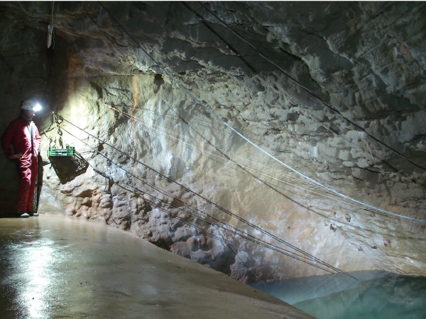
The Port Miou observation site is unique for the study of peri-Mediterranean karsts. It is spread over the Port-Miou watershed, overlapping the Huveaune watershed, and the surrounding watersheds (Le Las, La Reppe, Le Gapeau, Le Cauron, L’Issole). The Sainte-Baume mountain range forms a central culminating point, which receives a large part of the rainwater. Two isotope monitoring stations are deployed in the north and south of the massif. Inland, the physico-chemical evolution of various springs is monitored, as well as the main river Huveaune. At the outlet, the underwater spring of Port-Miou was developed in the 1970s, and is now an experimental laboratory. It is an artificial tunnel that allows access to the underground karstic gallery drowned 500 meters from the sea inland. Measurements are carried out on water (CTD, fluorescence, water isotopes, major ions) and on reservoir rocks (morphological evolution of the karst, 3D structures, geochemistry) at the scale of the regional hydrosystem.

The underground dam of the underground river and the artificial gallery form an exceptional site, with many assets :
The results obtained are exportable to continental karsts and to karsts around the Mediterranean.
The objective of an observatory site is to acquire data, repeated over a long period of time. The observation is spread over three study compartments of the critical zone: the atmosphere through measurements on precipitation water, rivers and groundwater in the basement.

In the watershed:
And at the outlet, on the Port-Miou underground site: